Property Record
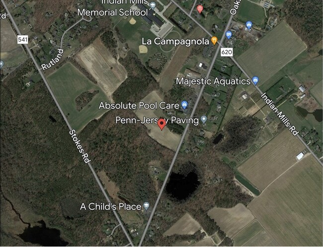
465 Oakshade Rd, Shamong, NJ 08088
This Property Is For Sale
NEARBY LISTINGS FOR SALE OR LEASE
Property Detail
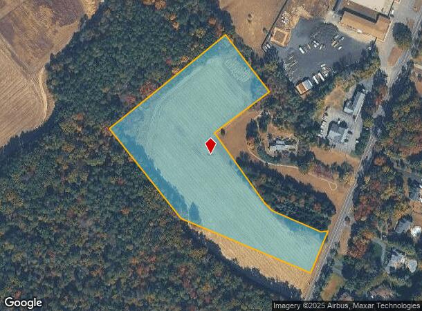
465 Oakshade Rd
Philadelphia-Camden-Wilmington, PA-NJ-DE-MD
ADDITIONAL LOTS: 24.05
32-00007-0000-00024-04-QFARM
Burlington
Farms
New Jersey
X
24.4
34005C0392F
23.87 AC
2024
South Burlington County
2025
Philadelphia
703700
DEMOGRAPHICS near 465 Oakshade Rd
1 Mile
3 Mile
5 Mile
2024 Total Population
1,062
10,111
25,059
2029 Population
1,074
10,221
25,319
Pop Growth 2024-2029
+ 1.13%
+ 1.09%
+ 1.04%
Average Age
41
41
42
2024 Total Households
361
3,372
8,593
HH Growth 2024-2029
+ 1.11%
+ 1.10%
+ 1.05%
Median Household Inc
$130,037
$133,470
$134,727
Avg Household Size
2.90
2.90
2.90
2024 Avg HH Vehicles
3.00
3.00
2.00
Median Home Value
$385,555
$410,707
$392,454
Median Year Built
1979
1979
1975
Nearby Places
Map Layers
Map Styles
 Street
 Aerial
- Restaurants
- Banks
- Shops
- Fitness
- Groceries
PUBLIC TRANSPORTATION
AIRPORT
Atlantic City International
DRIVE
WALK
Distance
Atlantic City International
64 min
34.0 mi
Philadelphia International
DRIVE
WALK
Distance
Philadelphia International
55 min
35.3 mi
Freight Ports
Broadway Terminal - Pier 5
DRIVE
WALK
Distance
Broadway Terminal - Pier 5
39 min
24.6 mi
Nearby Properties
Address
Land Use
TOTAL SIZE
Lot Size
Zoning
Address
Land Use
TOTAL SIZE
Lot Size
Zoning
48.43 AC
Address
Land Use
TOTAL SIZE
Lot Size
Zoning
727.21 AC
PPE
Address
Land Use
TOTAL SIZE
Lot Size
Zoning
17.27 AC
PVR
Address
Land Use
TOTAL SIZE
Lot Size
Zoning
37.84 AC
RGC
Address
Land Use
TOTAL SIZE
Lot Size
Zoning
81.20 AC
RGD
Address
Land Use
TOTAL SIZE
Lot Size
Zoning
1,284 SF
20.03 AC
Address
Land Use
TOTAL SIZE
Lot Size
Zoning
8.95 AC
RG
Address
Land Use
TOTAL SIZE
Lot Size
Zoning
40.08 AC
Address
Land Use
TOTAL SIZE
Lot Size
Zoning
136.15 AC
P
Address
Land Use
TOTAL SIZE
Lot Size
Zoning
25.48 AC
RD-I
Address
Land Use
TOTAL SIZE
Lot Size
Zoning
15.20 AC
Address
Land Use
TOTAL SIZE
Lot Size
Zoning
864 SF
4.54 AC
Address
Land Use
TOTAL SIZE
Lot Size
Zoning
1.37 AC
P
Address
Land Use
TOTAL SIZE
Lot Size
Zoning
1.27 AC
P
Address
Land Use
TOTAL SIZE
Lot Size
Zoning
14,176 SF
3 AC
PVI
Address
Land Use
TOTAL SIZE
Lot Size
Zoning
27,654 SF
3 AC
AP
Address
Land Use
TOTAL SIZE
Lot Size
Zoning
6,082 SF
6.92 AC
AP
Address
Land Use
TOTAL SIZE
Lot Size
Zoning
5,638 SF
1 AC
AP
Address
Land Use
TOTAL SIZE
Lot Size
Zoning
4,997 SF
21.87 AC
AP
Address
Land Use
TOTAL SIZE
Lot Size
Zoning
5,568 SF
3.06 AC
RGC
Address
Land Use
TOTAL SIZE
Lot Size
Zoning
17,792 SF
6.65 AC
RGC
Address
Land Use
TOTAL SIZE
Lot Size
Zoning
5,252 SF
0.73 AC
CC
Address
Land Use
TOTAL SIZE
Lot Size
Zoning
4,046 SF
19.49 AC
RD-4
Address
Land Use
TOTAL SIZE
Lot Size
Zoning
4,798 SF
1 AC
AP
Address
Land Use
TOTAL SIZE
Lot Size
Zoning
7.39 AC
Address
Land Use
TOTAL SIZE
Lot Size
Zoning
2 AC
PVR
Address
Land Use
TOTAL SIZE
Lot Size
Zoning
6 AC
PVC
Address
Land Use
TOTAL SIZE
Lot Size
Zoning
5,935 SF
1 AC
AP
Address
Land Use
TOTAL SIZE
Lot Size
Zoning
5,689 SF
1.01 AC
Address
Land Use
TOTAL SIZE
Lot Size
Zoning
3,784 SF
1.02 AC
AP
The World's #1 Commercial Real Estate Marketplace
Connect with us
© 2025 CoStar Group
The information above has been obtained from sources believed reliable. While we do not doubt its accuracy we have not verified it and make no guarantee, warranty or representation about it. It is your responsibility to independently confirm its accuracy and completeness. Any projections, opinions, assumptions, or estimates used are for example only and do not represent the current or future performance of the property. The value of this transaction to you depends on tax and other factors which should be evaluated by your tax, financial, and legal advisors. You and your advisors should conduct a careful, independent investigation of the property to determine to your satisfaction the suitability of the property for your needs.